
About the event
The SEATRa Cup's longest route will be challenging athletes on Sunday. A 76.8 kilometers route with 5500+ meters in elevation gain shall take participants will through the beautiful trails, villages and terraces in Bontoc. Participants must finish within 15 hours to be considered a finisher. Top three male and female will be awarded the gold, silver and bronze medals while the team champion (male and female) country for male and female shall bring home a symbolic Cordillera warrior armor as trophy.
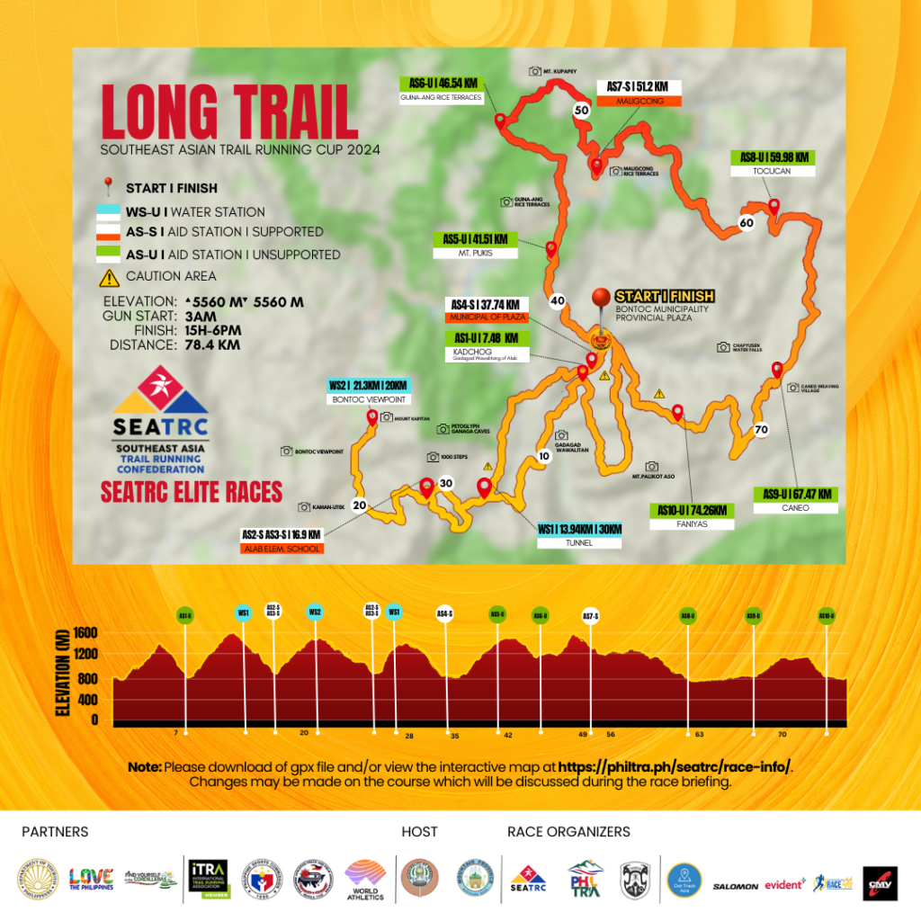
Course Map
- Start Time: 3AM, Sunday, June 23, 2024
- Cut-off Time: 37K - 8H 11am, June 23, 2024
- Cut-off Time: Finish Line - 15H 6pm, June 23, 2024
- Awarding: starts at 6pm, June 23, 2024 (or when podium is complete)
- COURSE: Trace de Trail : SEATRC - Long Trail
Course Profile
Their journey commences with a symbolic crossing of the bridge at CHICO RIVER (2 km from the starting line), a gateway to exploration. A gentle cruise through the verdant rice fields of Samoki Village sets the tone, offering a serene introduction to the trail ahead. They will then ascend a single-track trail, gaining about 680 meters of elevation over 5 kilometers as they reach the mountain peak of Palikot Aso. From here, they shall descend approximately 700 meters over 3 km+ to the first station. Participants delve into the embrace of a pine forest, where a mix of single-track, narrow, and fire road trails wind their way upward, offering panoramic views with each ascent and descent. Runners are advised to take extra caution on the single-track rope section where there is a strictly no-passing sign.
AS1: Kadchog AS
Coordinates: 17.08097838, 120.97231727
Location: Waiting Shed
Distance from Start: 7.48 km
Distance from Previous Section: 2.72 km
Cumulative Elevation Gain: 680 m
Cumulative Elevation Loss: 702 m
Runners will pass by a hanging bridge which takes them to the KADCHOG RICE TERRACES. An amazing view awaits them as it leads them also to the highest point of the course at GADAGAD WAWALITAN MOUNTAIN of Alab, which stands at 1710 meters above sea level. The ascent gives an 800-meter gain followed by a descent to the Water Station in Alab Oriente.
WS1 (Tunnel)
Coordinates: 17.05499363, 120.94987144
Distance from Start: 13.94 km
Distance from Previous Section: 5.92 km
Cumulative Elevation Gain: 1565 m
Cumulative Elevation Loss: 921 m
Runners will continue and turn left at the cross-section, descending the trails bringing them to Alab Elementary School.
AS2 (Alab Elementary School) - SUPPORTED
Coordinates: 17.05654159, 120.93840565
Distance from Start: 16.9 km
Distance from Previous Section: 2.96 km
Cumulative Elevation Gain: 1599 m
Cumulative Elevation Loss: 1521 m
This is a supported aid station. From AS2, runners will cross a bridge and exit the trails at Baguio-Bontoc Road. After crossing the street, they turn left and immediately turn right and enter the village (Signage: Welcome to Bilig Elementary School). Runners shall ascend until they reach the trails cross-section where they will turn right. This will be a continuous ascent to Bontoc View Point where a water station is located.
WS2 (Bontoc Viewpoint)
Coordinates: 17.07106039, 120.92555849
Distance from Start: 21.3 km
Distance from Previous Section: 4.4 km
Cumulative Elevation Gain: 2310 m
Cumulative Elevation Loss: 1582 m
They shall reach MOUNT KAIPITAN which is at 1600 meters above sea level. This is a favorite tourist spot where you can experience a nice sunrise view and a sea of clouds. Runners will make a U-turn at this WS until they reach the cross-section where they turn right heading back to the Alab Elementary School.
Runners will pass KAMAN-UTEK at this point. This is a famous tourist spot characterized by its strikingly blue-colored soil, due to the presence of copper sulfate minerals. This unique coloration creates a mesmerizing landscape that stands out amidst the surrounding greenery and pine trails.
Runners return back to Alab Elementary School Aid Station, exit the Baguio-Bontoc Road, turn left, and immediately turn right to the hanging bridge.
AS3 - S (Alab Elementary School)
Coordinates: 17.05654159, 120.93840565
Distance from Start: 27.2 km
Distance from Previous Section: 5.9 km
Cumulative Elevation Gain: 2380 m
Cumulative Elevation Loss: 2302 m
From Alab Elementary School Aid Station, runners will turn left at the cross-section taking them back to the Water Station.
WS1
Distance from Start: 29.47 km
Distance from Previous Section: 2.27 km
Cumulative Elevation Gain: 2948 m
Cumulative Elevation Loss: 2332 m
Runners will enter the trails taking them to the famous 1000 steps. This is the trail where trekkers pass to visit the GANGA CAVES (an ancient burial site) and PETROGLYPH (ancient writing on the walls).
Runners shall continue until they exit the trails where they shall head to the Supported Aid Station at the Municipal Plaza.
AS4 - S (Municipal Plaza)
Coordinates: 17.08640814, 120.97654737
Distance from Start: 37.74 km
Distance from Previous Section: 8.27 km
Cumulative Elevation Gain: 3068 m
Cumulative Elevation Loss: 3072 m
From the Plaza, the runners will ascend to Mount Fato - a beginner tourist trail known for offering the best view of the sunset. The ascent will cover about 500 meters gain over 5 kilometers, leading to the aid station (AS5). Runners of the 12k race will turn towards the trails heading to the finish line after passing through the Aid Station, with some sections of the route offering views of the Guinaang Rice Terraces.
AS5 (Mt. Fato)
Coordinates: 17.10540532, 120.96601513
Distance: 41.51 km
Distance from Previous Section: 3.76 km
Cumulative Elevation Gain: 3681 m
Cumulative Elevation Loss: 3100 m
The long trail, Tawid Marathon, and Half Marathon participants will continue running along the majestic view of Guinaang Rice Terraces until they reach the Aid Station (AS6), which is 5 kilometers away with a gain of 263 meters and a loss of 424 meters. From here, they will also reach Mount Kupapey, another frequently visited tourist hiking site where runners can experience running with a view of a sea of clouds on a clear day. This mountain is renowned as one of the best places to witness the sunrise.
AS6 (Guinaang Rice Terraces)
Coordinates: 17.13404432, 120.95425333
Distance: 46.54 km
Distance from Previous Section: 5.03 km
Cumulative Elevation Gain: 3944 m
Cumulative Elevation Loss: 3524 m
Runners will then descend to the Maligcong Rice Terraces, a UNESCO)-Greece Melina Mercouri International Prize for the Safeguarding and Management of Cultural Landscapes nominee, with a rolling terrain and a gain of 268 meters and a descent of 420 meters until they reach the next aid station (AS7). Runners of the Tawid Half Marathon shall turn towards the finish line. Meanwhile, the Long Trail and Tawid Marathon participants will continue their run along the magnificent path of Maligcong Terraces.
AS7 - S (Maligcong)
Coordinates: 17.12392606, 120.97491048
Distance: 51.2 km
Distance from Previous Section: 4.66 km
Cumulative Elevation Gain: 4422 m
Cumulative Elevation Loss: 3986 m
By June, the rice crops have turned the whole stairways of the terraces green. Runners will enjoy this view and a rolling terrain of almost nine kilometers with a gain of 287 meters and a loss of 768 meters until they reach the next aid station (AS8) in Tocucan.
AS8 (Tocucan)
Coordinates: 17.11666947, 121.01468846
Distance: 59.98 km
Distance from Previous Section: 8.78 km
Cumulative Elevation Gain: 4709 m
Cumulative Elevation Loss: 4702 m
Along the route, they'll catch a glimpse again of the longest river in the Philippines, the Chico River. Runners will then pass through a mix of forest trails, grasslands, fire roads, and villages for 7.5 kilometers with a 304-meter elevation gain and a 287-meter elevation loss until they reach the aid station in Caneo (AS9). Runners will pass through the Chapyusen Waterfalls in this part. There are more waterfalls in this part of the trails which may be worth visiting on another trip. Caneo is also known as the weaving village.
AS9 (Caneo)
Coordinates: 17.07700133, 121.01185395
Distance: 67.47 km
Distance from Previous Section: 7.49 km
Cumulative Elevation Gain: 5013 m
Cumulative Elevation Loss: 4989 m
After the Caneo Village, runners shall have a 6.79-kilometer stretch with a 450-meter elevation gain and a 436-meter elevation loss through grasslands, forest trails, pine forests, and a mix of running through villages until they reach AS10 in Faniyas.
AS10 (Faniyas)
Coordinates: 17.07493992, 120.98619032
Distance: 74.26 km
Distance from Previous Section: 6.79 km
Cumulative Elevation Gain: 5463 m
Cumulative Elevation Loss: 5425 m
After AS10, runners will have a 2.87-kilometer run to the finish line at the Provincial Plaza.
Finish Line
Coordinates: 17.09051134, 120.97695216
Distance: 76.72 km
Distance from Previous Section: 2.46 km
Cumulative Elevation Gain: 5508 m
Cumulative Elevation Loss: 5512 m