
About the event
The SEATRa Cup's short trail route will be challenging athletes on Sunday. A 36.9 kilometers route with 3079+ meters in elevation gain shall take participants will through the beautiful trails, villages and terraces in Bontoc. Participants must finish within 8 hours to be considered a finisher. Top finishers male and female will receive the Gold, Silver and Bronze medals. Team Champion for Male and Female will receive a special warrior trophy.
Course Map
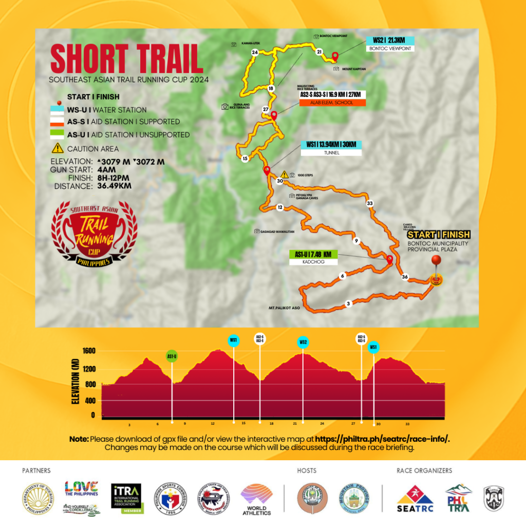
- Start Time: 4AM, Sunday, June 23, 2024
- Cut-off Time: Finish Line - 12 noon, June 23, 2024
- Awarding: 3pm, June 23, 2024
- COURSE PREVIEW: Trace de Trail : SEATRC-Short Trail
Course Profile
Their journey commences with a symbolic crossing of the bridge at CHICO RIVER (2 km from the starting line), a gateway to exploration. A gentle cruise through the verdant rice fields of Samoki Village sets the tone, offering a serene introduction to the trail ahead. They will then ascend a single-track trail, gaining about 680 meters of elevation over 5 kilometers as they reach Palikot Aso mountain peak. From here, they shall descend approximately 700 meters over 3 km+ to the first station. Participants delve into the embrace of a pine forest, where a mix of single-track, narrow, and fire road trails wind their way upward, offering panoramic views with each ascent and descent. Runners are advised to take extra caution on the single-track rope section where there is a strictly no-passing sign.
AS1: Kadchog AS
Coordinates: 17.08097838, 120.97231727
Location: Waiting Shed
Distance from Start: 7.48 km
Distance from Previous Section: 2.72 km
Cumulative Elevation Gain: 680 m
Cumulative Elevation Loss: 702 m
Runners will pass by a hanging bridge which takes them to the KADCHOG RICE TERRACES. An amazing view awaits them as it leads them also to the highest point of the course at GADAGAD WAWALITAN MOUNTAIN of Alab, which stands at 1710 meters above sea level. The ascent gives an 800-meter gain followed by a descent to the Water Station in Alab Oriente.
WS1 (Tunnel)
Coordinates: 17.05499363, 120.94987144
Distance from Start: 13.94 km
Distance from Previous Section: 5.92 km
Cumulative Elevation Gain: 1565 m
Cumulative Elevation Loss: 921 m
Runners will continue and turn left at the cross-section, descending the trails bringing them to Alab Elementary School.
AS2 (Alab Elementary School) - SUPPORTED
Coordinates: 17.05654159, 120.93840565
Distance from Start: 16.9 km
Distance from Previous Section: 2.96 km
Cumulative Elevation Gain: 1599 m
Cumulative Elevation Loss: 1521 m
This is a supported aid station. From AS2, runners will cross a bridge and exit the trails at Baguio-Bontoc Road. After crossing the street, they turn left and immediately turn right and enter the village (Signage: Welcome to Bilig Elementary School). Runners shall ascend until they reach the trails cross-section where they will turn LEFT. This will be a continuous ascent to Bontoc View Point where a water station is located.
WS2 (Bontoc Viewpoint)
Coordinates: 17.07106039, 120.92555849
Distance from Start: 21.3 km
Distance from Previous Section: 4.4 km
Cumulative Elevation Gain: 2310 m
Cumulative Elevation Loss: 1582 m
They shall reach MOUNT KAIPITAN which is at 1600 meters above sea level. This is a favorite tourist spot where you can experience a nice sunrise view and a sea of clouds. Runners will make a U-turn at this WS until they reach the cross-section where they turn right heading back to the Alab Elementary School.
Runners will pass KAMAN-UTEK at this point. This is a famous tourist spot characterized by its strikingly blue-colored soil, due to the presence of copper sulfate minerals. This unique coloration creates a mesmerizing landscape that stands out amidst the surrounding greenery and pine trails.
Runners return back to Alab Elementary School Aid Station, exit the Baguio-Bontoc Road, turn left, and immediately turn right to the hanging bridge.
AS3 - S (Alab Elementary School)
Coordinates: 17.05654159, 120.93840565
Distance from Start: 27.2 km
Distance from Previous Section: 5.9 km
Cumulative Elevation Gain: 2380 m
Cumulative Elevation Loss: 2302 m
From Alab Elementary School Aid Station, runners will turn left at the cross-section taking them back to the Water Station.
WS1 (Tunnel)
Coordinates: 17.05499363, 120.94987144
Distance from Start: 29.47 km
Distance from Previous Section: 2.27 km
Cumulative Elevation Gain: 2948 m
Cumulative Elevation Loss: 2332 m
Runners will enter the trails taking them to the famous 1000 steps. This is the trail where trekkers pass to visit the GANGA CAVES (an ancient burial site) and PETROGLYPH (ancient writing on the walls).
Runners shall continue until they exit the trails where they shall head to the Finish Line.
FINISH LINE
Coordinates: 17.09051134, 120.97695216
Distance from Start: 36.49 km
Distance from Previous Section: 7.9 km
Cumulative Elevation Gain: 3079 m
Cumulative Elevation Loss: 3072 m