
About the event
The Tawid Mountain Marathon, on its eight year, is the Open Category of the Southeast Asian Trail Running Cup. Participants will be ranked in the SEATRA Cup's Age Group and ITRA Index Points. Local (Filipino) participants will also earn Philtra Qualifier ranking points and ITRA index points for the ITRA National League.
Course Map-42K
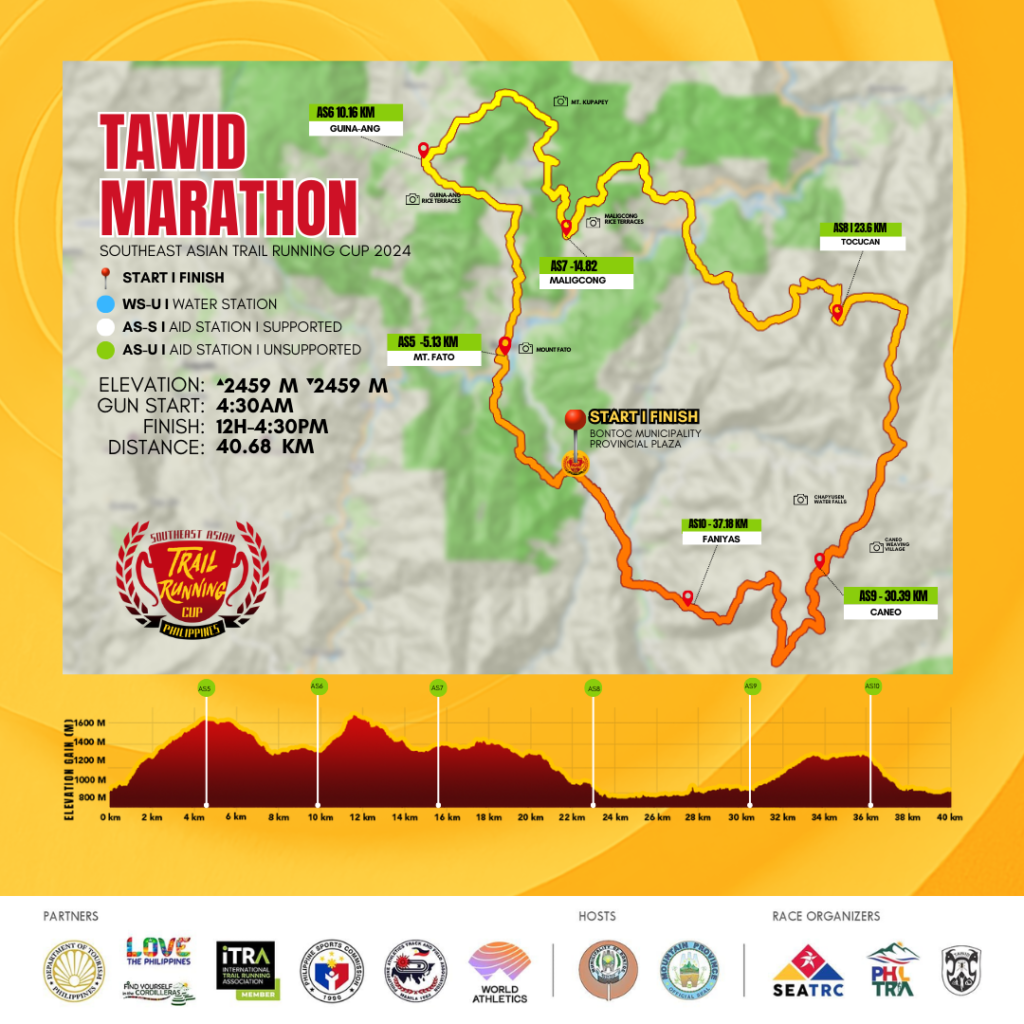
- Start Time: 4:30AM, Sunday, June 23, 2024
- Intermediate Cut-off: AS 2 (KM 17) - 4H at 8:30am
- Cut-off Time: (12H) Finish Line - 4pm, June 23, 2024
- Awarding: starts at 3pm, June 23, 2024
- COURSE INFO: Trace de Trail : SEATRC-Tawid Marathon
Course Map-21K
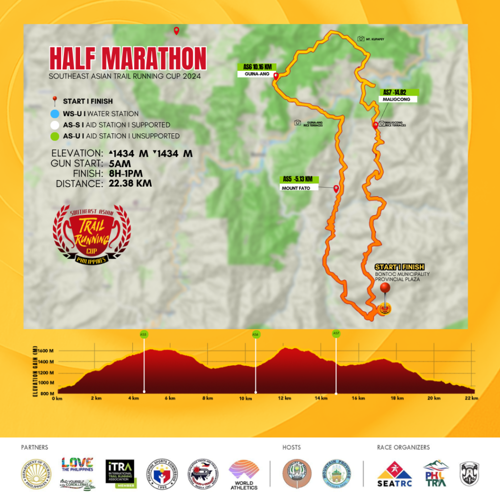
- Start Time: 5:00AM, Sunday, June 23, 2024
- Intermediate Cut-off: 4H or 9am at AS2 KM17 (Maligcong)
- Cut-off Time: (8H) Finish Line - 1pm, June 23, 2024
- Awarding: starts at 3pm, June 23, 2024
- COURSE INFO: Trace de Trail : SEATRC-TAWID HALF MARATHON
Course Map-12K
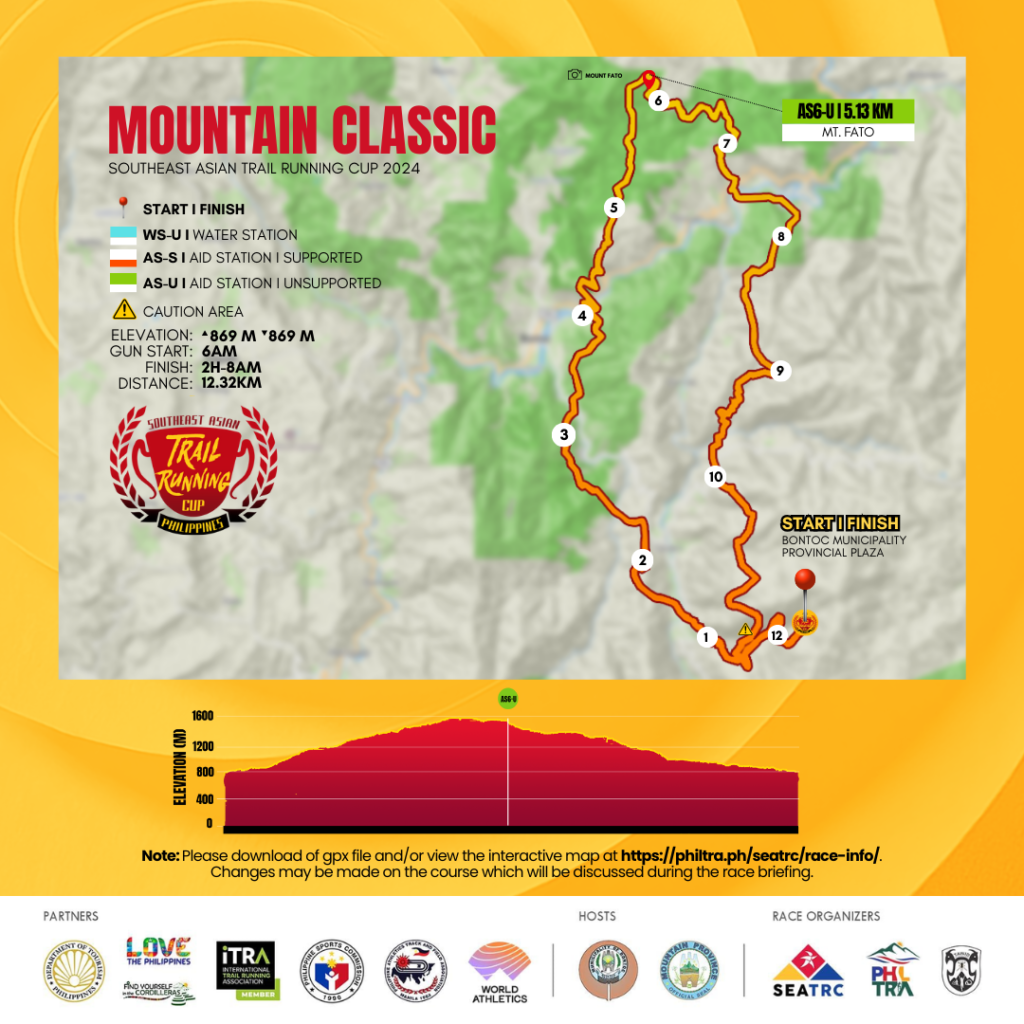
- Start Time: 630AM, Sunday, June 23, 2024
- Cut-off Time: (5H) Finish Line - 1130Am, June 23, 2024
- Awarding: starts at 3pm, June 23, 2024
- COURSE INFO: Trace de Trail : SEATRC-TAWID MOUNTAIN CLASSIC
COURSE INFO
From the Plaza, the runners will ascend to Mount Fato - a beginner tourist trail known for offering the best view of the sunset. The ascent will cover about 613 meters gain over 3.77 kilometers, leading to the aid station (AS5). Runners of the 12k race will turn towards the trails heading to the finish line after passing through the Aid Station, with some sections of the route offering views of the Guinaang Rice Terraces.
AS6 (Mt Fato)
- Coordinates: 17.10540532, 120.96601513
- Distance from Start: 5.13 km
- Distance from Previous Section: 5.13 km
- Cumulative Elevation Gain: 613 m
- Cumulative Elevation Loss: 28 m
The Long Trail, Tawid Marathon, and Half Marathon participants will continue running along the majestic view of Guinaang Rice Terraces until they reach the Aid Station (AS6), which is 5 kilometers away with a gain of 263 meters and a loss of 424 meters. From here, they will also reach Mount Kupapey, another frequently visited tourist hiking site where runners can experience running with a view of a sea of clouds on a clear day. This mountain is renowned as one of the best places to witness the sunrise.
AS6 (Guinaang Rice Terraces)
- Coordinates: 17.13404432, 120.95425333
- Distance from Start: 10.16 km
- Distance from Previous Section: 5.03 km
- Cumulative Elevation Gain: 876 m
- Cumulative Elevation Loss: 452 m
Runners will then descend to the Maligcong Rice Terraces, a UNESCO)-Greece Melina Mercouri International Prize for the Safeguarding and Management of Cultural Landscapes nominee, with a rolling terrain and a gain of 268 meters and a descent of 420 meters until they reach the next aid station (AS7). Runners of the Tawid Half Marathon shall turn towards the finish line. Meanwhile, the Long Trail and Tawid Marathon participants will continue their run along the magnificent path of Maligcong Terraces.
AS7 - S (Maligcong)
- Coordinates: 17.12392606, 120.97491048
- Distance from Start: 14.82 km
- Distance from Previous Section: 4.66 km
- Cumulative Elevation Gain: 1354 m
- Cumulative Elevation Loss: 914 m
By June, the rice crops have turned the whole stairways of the terraces green. Runners will enjoy this view and a rolling terrain of almost nine kilometers with a gain of 287 meters and a loss of 768 meters until they reach the next aid station (AS8) in Tocucan.
AS8 (Tocucan)
- Coordinates: 17.11666947, 121.01468846
- Distance from Start: 23.6 km
- Distance from Previous Section: 8.78 km
- Cumulative Elevation Gain: 1641 m
- Cumulative Elevation Loss: 1630 m
Along the route, they'll catch a glimpse again of the longest river in the Philippines, the Chico River. Runners will then pass through a mix of forest trails, grasslands, fire roads, and villages for 7.5 kilometers with a 304-meter elevation gain and a 287-meter elevation loss until they reach the aid station in Caneo (AS9). Runners will pass through the Chapyusen Waterfalls in this part. There are more waterfalls in this part of the trails which may be worth visiting on another trip. Caneo is also known as the weaving village.
AS9 (Caneo)
- Coordinates: 17.07700133, 121.01185395
- Distance from Start: 30.39 km
- Distance from Previous Section: 6.79 km
- Cumulative Elevation Gain: 1945 m
- Cumulative Elevation Loss: 1917 m
After the Caneo Village, runners shall have a 6.79-kilometer stretch with a 450-meter elevation gain and a 436-meter elevation loss through grasslands, forest trails, pine forests, and a mix of running through villages until they reach AS10 in Faniyas.
AS10 (Faniyas)
- Coordinates: 17.07493992, 120.98619032
- Distance from Start: 37.18 km
- Distance from Previous Section: 6.79 km
- Cumulative Elevation Gain: 2395 m
- Cumulative Elevation Loss: 2353 m
After AS10, runners will have a 2.87-kilometer run to the finish line at the Provincial Plaza.
Finish Line
- Coordinates: 17.09051134, 120.97695216
- Distance from Start: 40.9 km
- Distance from Previous Section: 3.72 km
- Cumulative Elevation Gain: 2440 m
- Cumulative Elevation Loss: 2440 m
CHECK COURSE INFO FOR ALL RACES HERE.
Course Profile
[row_inner_3]
[col_inner_3 span__sm="12"]
[/col_inner_3]
[/row_inner_3]
GENERAL RULES
1. It is the athlete’s responsibility to understand and know the rules and regulations before entering the course and participating in the competition.
2. Cut off time is 12 hours for 42K and 8 Hours for 24km and 5 Hours for 12km; failure to finish the race within the cut off time will mean a DNF (Did Not Finish) status on the race result. (Cut-off may change which will be announced in this page)
3. Athletes are not allowed to race bare chested. We must respect the culture of the people living in the race area. Failure to comply to this rule might result in disqualification from the race.
4. Athletes are required to report to the start area 1 hour prior to the start of their designated wave for mandatory gear check and short briefing and reminders. Reporting too late can result in not being able to start at all or having to start in a later start group. The organization can decide if the time for starting later will be compensated or not.
6. For those parts of the course that public roads are used, athletes must respect traffic regulations and behave like how (running) pedestrians are expected to behave.
7. Deliberately blocking other competitors progress will result in disqualification.
8. There will be no (time) compensation in case the competitor is blocked by another competitor, official, any other person or anything else.
9. Athletes are required to provide and accept assistance from other competitors in distress, whose safety, is endangered and/or who require medical assistance, up and until the moment this role has been taken over by volunteers or medical staff.
10. Outside assistance:
- Limited outside assistance is allowed from another athlete competing in the same event.
0 No outside assistance is allowed from any person not competing in the same event. These include but are not limited to spectators, friends, family, volunteers, support crew, photographers, police or marshals
11. Athletes are obligated to:
- Know, understand and follow the rules and regulations at all times
- Practice good sportsmanship at all times
- Be responsible for their own safety and the safety of others
- Obey instructions from race officials and event staff at all times
- Treat other athletes, officials, volunteers, media, sponsors and spectators with respect and courtesy
- Not dispose litter or equipment on or around the course except at clearly designated places. All items must be kept with the athlete and disposed of appropriately at the end of the race
- Not attempt to gain unfair advantages in any way
- Have to be present at the briefing which starts 1 hour before the first start group starts.
There will be Water refilling stations along the Race Course. It’s a must that you bring your own water bottle or Hydration packs to ensure proper hydration all throughout the race, no paper cups will be provided during the race and racers will be required to refill their own hydration system from the water containers provided in the stations.
42km: Each racer must be self-contained/ self-reliant complete with the following mandatory items:
- Headlamp with extra battery
- Jacket
- Hydration bottle/ pack (at least 1.5L)
- Trail food/ water
- First aid kit
- Whistle
- Emergency blanket
- Foldable Cup or bowl
25km: Each racer must be self-contained/ self-reliant complete with the following mandatory items:
- Headlamp
- Jacket
- Hydration bottle/ pack (at least 800ml)
- Trail food/ water
- Whistle
- Emergency blanket
- Foldable Cup or bowl
12km: Each runner must be self-contained/ self-reliant. Complete with the following mandatory items:
- · Hydration bottle/ pack (at least 800ml)
- · Water
- · Whistle
- · Trail Food (optional)
- · Jacket (Optional)
- · Emergency blanket
NOTE: These mandatory items will be inspected upon check-in at the starting line and during the race. Mandatory items may change depending on the weather and trail condition.
Participants should prepare and gear up for the high altitude and cold weather conditions in the mountain trails.